* Undeveloped land on Southfield Freeway just north of West Chicago
* Located in the Joy Community with nearly 3000 residents providing an urban-residential feel.
* Just 1.5 miles from Stoepel Park and a mile from the Stein Playground.
* Under three miles from the historic Islamic Center of Detroit (ICD) a staple of the Detroit- Dearborn community.
* Prime undeveloped land along the Grand River Avenue Corridor.
* Central location within Core City, near the historic Corktown and Woodbridge neighborhoods, and less than 1.5 miles from many downtown attractions and institutions.
* Just past the northwest border of Corktown and Woodbridge is the close-knit community of Core City. Over the years, the nonprofit Core City Neighborhoods Inc. has helped lead the effort to build homes, including about 100 single-family houses and townhomes in the early 2000s.
* Two DDOT Transit Stations at site location, with dedicated bike facilities along corridor.
* Situated nearby the historic Redford Theatre, Henry Ford High School, Plum Hollow Country Club.
* The site sits between the M-10 Lodge and I-75 Interchange and the I-96 Jefferies and I-94 Edsel Ford Interchange.
- 0.6 acres of undeveloped land between the Jefferson Avenue Corridor and I-75.
Located in the Melvindale neighborhood of Detroit, near the City of Allen Park and the Oakdale Heights neighborhood.
Providing an urban feel only a couple miles from the Ford Rouge Complex, which employs 6,000 workers.
- A quarter-acres, zoned in B4, in the District 6. A growing area holding a strong contingent of Wayne State University graduates and millennial population within Detroit.
Just off I-94 Edsel Ford Freeway and Livernois Avenue exit, the site will support a considerable amount of traffic as residents and workers commute to and from work.Undeveloped land located in the Midwest Tireman neighborhood.
The neighborhood is bounded by Warren Avenue to the north, Junction Street to the east, John Kronk Street to the south and Wyoming Avenue to the west.
One mile north of I-94 highway at the Livernois Avenue exit.
Located in an industrial region, the area is home to a number of large manufacturing facilities with a extensive number of workers.
- * Prime undeveloped land on the Gratiot Avenue Corridor.
* Nestled in a residential corridor, with over 600 single-family homes and two public parks in Pingree Park, named for former Detroit Mayor Hazen Pingree.
* Located .37 miles from M-53 and .58 miles from I-94, and nearby Van Dyke Avenue.
* Located nearby multiple retail and auto repair locations, including A1 Auto Repair and Muffler; Wade’s Automotive Service and Towing; East Coast Collision.
* Within one mile of Factory Zero, GM’s new $2,2 B manufacturing facility for electric vehicles, which employs about 2,200 workers. Within 1.5 miles of the Stellantis Mack Assembly Plant, which employs over 5,500 workers.
* Located nearby significant multi-family and single-family residential units.
* Has four bus stops within walking distance from the site location.
* Located in a Neighborhood Revitalization Strategy Areas 2020 NRSA_1.
- Prime undeveloped land on the East Jefferson Avenue Corridor.
Nestled in a historic residential corridor, with over 1,600 single-family homes, three schools and two public parks. 85% of homes in this neighborhood are owner-occupied.
Located .37 miles from M-53 and .58 miles from I-94, and nearby Van Dyke Avenue.
Located nearby multiple retail and service locations, including Grosse Pointe Moving & Storage, Parkway Foods, and the Jefferson Veterinary Center, Pathways Academy, 9 to 9 Beauty Supply and Detroit Enterprise Academy. It is also located next to AT&T Central Office, Great Lakes Export, US Border Patrol Station, DO All Plastic, Nationwide Recovery, Spencer/ Butcher Group Assemble Rite and the Stellantis Detroit River Yard.
Within one block of the Stellantis Jefferson North Assembly Plant, which employs over 5,000 workers.
Has eight DDOT bus stops within walking distance from the site location.
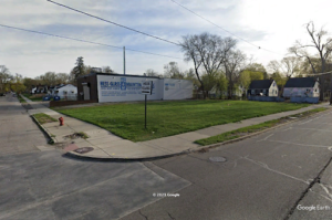
- Located in the historic neighborhood of Cadillac Heights on East McNichols Road just west of Dequindre Road.
Just north of the City of Hamtramck, Cadillac Heights is home to Ford Park and the Detroit Golf Club is less than a mile away.
A quarter mile from I-75 / McNichols Road Freeway exit, creating a great amount of through traffic. North of Ebenezer Church a large faith-based institution within Cadillac Heights.
Less than a half-mile from Caramagno Foods, a popular grocery store in the area and only a short distance west of Buddy’s Pizza, a local favorite.
- Premium undeveloped land on Wyoming Avenue just south of 7 Mile Road
Only about 300 feet south of 7 Mile Road at the northwest corner of the historic Bagley neighborhood, adjacent to University District
Just a couple miles from the Detroit Golf Club and even less to Marygrove College and the famous local eatery, Lou’s Deli.
- Prime undeveloped on Wyoming Avenue at a very desirable corner with high traffic off John C Lodge Freeway (M-10).Enclosed by Fenkell Avenue, McNichols Road, Livernois Avenue, Meyers Avenue/ M-10/ the Lodge Freeway. This neighborhood has access to Mary McCloud Bethune Elementary-Middle School
Under two miles from University of Detroit Mercy and Marygrove College and the community is also home to the Maggie Lee Community Center a little over a half-mile mile away
Fitzgerald lies within the Livernois and McNichols “Live6” corridor, giving community members access to Detroit’s Avenue of Fashion and various shops, art galleries, salons, and restaurants.
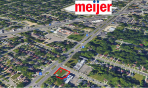
- Prime undeveloped land near the intersection of the McNichols Road and the West Grand River Avenue Corridor
- Central location near Holcomb Street, near the historic Old Redford neighborhood, and less than 1.5 miles from Telegraph Road, Southfield Freeway, and Redford Charter Township. It is also two miles away from I-96.
- This site is included in the Grand River Northwest Framework Plan which includes a dynamic revitalization plan that includes: Holcomb Elementary Site redevelopment to multi-family housing units and open space amenities; 2017 Design Center in a Box, funded by 2017 Knight Cities Challenge storefront activations; the Obama Building (8,880 sq/ft of retail and four residential units); a multi-family redevelopment at the Burt Road site; Old Redford Link, a neighborhood greenway with a public art exhibit; redesigned Grand River streetscape improvements; GRANDparklet – a flexible community plaza; and a single-family stabilization area.
- Three DDOT Transit Stations are within two blocks of the site location.
- The site sits between the Telegraph Road (west) and Southfield Freeway (east) and Seven Mile Road (north) and I-96 (south). It is also nearby Outer Drive, a main road for daily travel.
- Situated nearby the historic Redford Theatre, Henry Ford High School, Plum Hollow Country Club
- Located in a Neighborhood Revitalization Strategy Areas 2020 NRSA_5.